


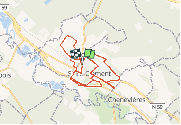
sortie vtt du 11112020 km st clément

fabwin
User GUIDE

Length
18.9 km

Max alt
275 m

Uphill gradient
117 m
Km-Effort
21 km

Min alt
234 m

Downhill gradient
116 m
Boucle
Yes
Creation date :
2020-11-11 07:57:46.246
Updated on :
2020-11-11 10:18:27.014
1h00
Difficulty : Very easy

FREE GPS app for hiking
 SityTrail
IGN / Geographical institutes
SityTrail Plus
The world is yours!
About
Trail Mountain bike of 18.9 km to be discovered at Grand Est, Meurthe-et-Moselle, Saint-Clément. This trail is proposed by fabwin.
Description
Sortie du jour en respectant la règle (alac) du km autour de chez soi.
La grisaille était au rendez-vous mais cela fait du bien de pouvoir bouger un peu.
Positioning
Country:
France
Region :
Grand Est
Department/Province :
Meurthe-et-Moselle
Municipality :
Saint-Clément
Location:
Unknown
Start:(Dec)
Start:(UTM)
323009 ; 5378516 (32U) N.
Comments