


JF_31-10-20_traces

ajd26
User
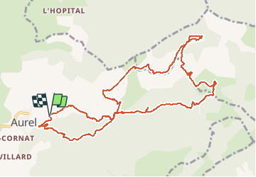

Length
13.1 km

Max alt
1126 m

Uphill gradient
759 m
Km-Effort
23 km

Min alt
443 m

Downhill gradient
759 m
Boucle
Yes
Creation date :
2020-11-11 15:49:50.743
Updated on :
2020-11-11 16:23:02.223
4h30
Difficulty : Medium

FREE GPS app for hiking
 SityTrail
IGN / Geographical institutes
SityTrail Plus
The world is yours!
About
Trail Walking of 13.1 km to be discovered at Auvergne-Rhône-Alpes, Drôme, Aurel. This trail is proposed by ajd26.
Description
grp_trc:
Positioning
Country:
France
Region :
Auvergne-Rhône-Alpes
Department/Province :
Drôme
Municipality :
Aurel
Location:
Unknown
Start:(Dec)
Start:(UTM)
682635 ; 4951756 (31T) N.
Comments