


Calmont 3

richardsimopons
User
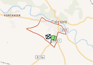

Length
6.6 km

Max alt
227 m

Uphill gradient
42 m
Km-Effort
7.2 km

Min alt
209 m

Downhill gradient
42 m
Boucle
Yes
Creation date :
2020-11-12 08:23:28.0
Updated on :
2020-11-12 10:03:41.447
1h40
Difficulty : Unknown

FREE GPS app for hiking
 SityTrail
IGN / Geographical institutes
SityTrail Plus
The world is yours!
About
Trail Walking of 6.6 km to be discovered at Occitania, Haute-Garonne, Calmont. This trail is proposed by richardsimopons.
Description
Encore la boucle!!!!
Photos


Positioning
Country:
France
Region :
Occitania
Department/Province :
Haute-Garonne
Municipality :
Calmont
Location:
Unknown
Start:(Dec)
Start:(UTM)
388628 ; 4792418 (31T) N.
Comments