


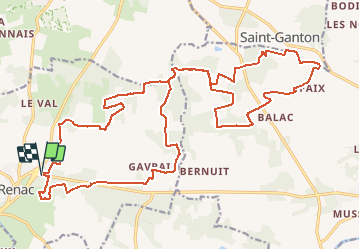
12/11/2020 - De RENAC à LA CHAPELLE DE GAVRAIN à ST GANTON.Virtuel

babeth35
User

Length
29 km

Max alt
104 m

Uphill gradient
416 m
Km-Effort
35 km

Min alt
23 m

Downhill gradient
409 m
Boucle
Yes
Creation date :
2020-11-12 13:26:22.267
Updated on :
2020-11-12 17:44:30.286
--
Difficulty : Medium
59m
Difficulty : Easy

FREE GPS app for hiking
 SityTrail
IGN / Geographical institutes
SityTrail Plus
The world is yours!
About
Trail On foot of 29 km to be discovered at Brittany, Ille-et-Vilaine, Renac. This trail is proposed by babeth35.
Positioning
Country:
France
Region :
Brittany
Department/Province :
Ille-et-Vilaine
Municipality :
Renac
Location:
Unknown
Start:(Dec)
Start:(UTM)
577492 ; 5286026 (30T) N.
Comments