


puech fayssel

lablaquiere
User
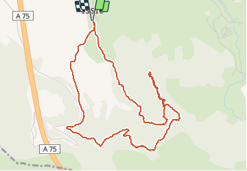

Length
6.1 km

Max alt
708 m

Uphill gradient
305 m
Km-Effort
10.2 km

Min alt
436 m

Downhill gradient
304 m
Boucle
Yes
Creation date :
2020-11-12 14:08:01.973
Updated on :
2020-11-12 15:55:46.437
1h47
Difficulty : Very easy

FREE GPS app for hiking
 SityTrail
IGN / Geographical institutes
SityTrail Plus
The world is yours!
About
Trail Walking of 6.1 km to be discovered at Occitania, Aveyron, Creissels. This trail is proposed by lablaquiere.
Positioning
Country:
France
Region :
Occitania
Department/Province :
Aveyron
Municipality :
Creissels
Location:
Unknown
Start:(Dec)
Start:(UTM)
502577 ; 4880199 (31T) N.
Comments