


tour de gaël 99% chemin devant le château

PatriceCocuaud
User
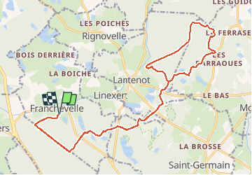

Length
25 km

Max alt
434 m

Uphill gradient
409 m
Km-Effort
31 km

Min alt
299 m

Downhill gradient
409 m
Boucle
Yes
Creation date :
2020-11-14 10:18:01.937
Updated on :
2020-11-14 13:36:44.69
3h16
Difficulty : Easy

FREE GPS app for hiking
 SityTrail
IGN / Geographical institutes
SityTrail Plus
The world is yours!
About
Trail Mountain bike of 25 km to be discovered at Bourgogne-Franche-Comté, Haute-Saône, Franchevelle. This trail is proposed by PatriceCocuaud.
Positioning
Country:
France
Region :
Bourgogne-Franche-Comté
Department/Province :
Haute-Saône
Municipality :
Franchevelle
Location:
Unknown
Start:(Dec)
Start:(UTM)
309563 ; 5290302 (32T) N.
Comments