


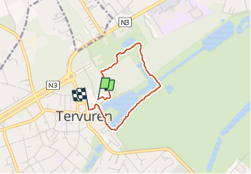
Tervuren

šarūnas
User

Length
2.3 km

Max alt
94 m

Uphill gradient
45 m
Km-Effort
2.9 km

Min alt
61 m

Downhill gradient
47 m
Boucle
Yes
Creation date :
2020-11-14 14:43:12.0
Updated on :
2020-11-14 15:20:11.001
37m
Difficulty : Very easy

FREE GPS app for hiking
 SityTrail
IGN / Geographical institutes
SityTrail Plus
The world is yours!
About
Trail Walking of 2.3 km to be discovered at Flanders, Flemish Brabant, Tervuren. This trail is proposed by šarūnas.
Positioning
Country:
Belgium
Region :
Flanders
Department/Province :
Flemish Brabant
Municipality :
Tervuren
Location:
Tervuren
Start:(Dec)
Start:(UTM)
606752 ; 5631510 (31U) N.
Comments