


BM-15.11.2020

bene_dictus77
User

Length
4.5 km

Max alt
44 m

Uphill gradient
22 m
Km-Effort
4.8 km

Min alt
34 m

Downhill gradient
21 m
Boucle
Yes
Creation date :
2020-11-15 06:21:37.506
Updated on :
2020-11-15 07:19:29.48
55m
Difficulty : Very easy

FREE GPS app for hiking
 SityTrail
IGN / Geographical institutes
SityTrail Plus
The world is yours!
About
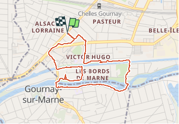
Trail Walking of 4.5 km to be discovered at Ile-de-France, Seine-et-Marne, Chelles. This trail is proposed by bene_dictus77.
Description
Rando dans le périmètre autorisé.
Positioning
Country:
France
Region :
Ile-de-France
Department/Province :
Seine-et-Marne
Municipality :
Chelles
Location:
Unknown
Start:(Dec)
Start:(UTM)
468995 ; 5413196 (31U) N.
Comments