


boucle quincieux

ophness
User
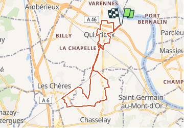

Length
17.6 km

Max alt
219 m

Uphill gradient
112 m
Km-Effort
19.1 km

Min alt
164 m

Downhill gradient
115 m
Boucle
Yes
Creation date :
2020-11-17 11:23:54.787
Updated on :
2020-11-17 11:24:45.987
--
Difficulty : Very easy

FREE GPS app for hiking
 SityTrail
IGN / Geographical institutes
SityTrail Plus
The world is yours!
About
Trail Equestrian of 17.6 km to be discovered at Auvergne-Rhône-Alpes, Métropole de Lyon, Quincieux. This trail is proposed by ophness.
Positioning
Country:
France
Region :
Auvergne-Rhône-Alpes
Department/Province :
Métropole de Lyon
Municipality :
Quincieux
Location:
Unknown
Start:(Dec)
Start:(UTM)
638732 ; 5086569 (31T) N.
Comments