


transhumance quincieux sgmo

ophness
User
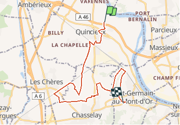

Length
15.5 km

Max alt
242 m

Uphill gradient
151 m
Km-Effort
17.3 km

Min alt
169 m

Downhill gradient
83 m
Boucle
No
Creation date :
2020-11-18 13:14:13.985
Updated on :
2020-11-18 13:14:36.467
--
Difficulty : Very easy

FREE GPS app for hiking
 SityTrail
IGN / Geographical institutes
SityTrail Plus
The world is yours!
About
Trail Equestrian of 15.5 km to be discovered at Auvergne-Rhône-Alpes, Métropole de Lyon, Quincieux. This trail is proposed by ophness.
Positioning
Country:
France
Region :
Auvergne-Rhône-Alpes
Department/Province :
Métropole de Lyon
Municipality :
Quincieux
Location:
Unknown
Start:(Dec)
Start:(UTM)
638304 ; 5086584 (31T) N.
Comments