


Auxerre - Cravant

JackyCouturier
User
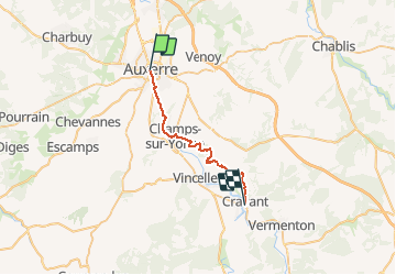

Length
23 km

Max alt
282 m

Uphill gradient
475 m
Km-Effort
30 km

Min alt
98 m

Downhill gradient
487 m
Boucle
No
Creation date :
2020-11-18 16:46:42.426
Updated on :
2020-11-19 17:09:04.883
21m
Difficulty : Easy

FREE GPS app for hiking
 SityTrail
IGN / Geographical institutes
SityTrail Plus
The world is yours!
About
Trail Walking of 23 km to be discovered at Bourgogne-Franche-Comté, Yonne, Auxerre. This trail is proposed by JackyCouturier.
Description
Chemin de Compostelle
Paris - Vézelay
Positioning
Country:
France
Region :
Bourgogne-Franche-Comté
Department/Province :
Yonne
Municipality :
Auxerre
Location:
Unknown
Start:(Dec)
Start:(UTM)
542752 ; 5293638 (31T) N.
Comments