


domaine Galy

Mascart
User
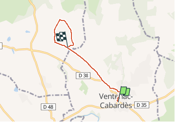

Length
4.6 km

Max alt
189 m

Uphill gradient
89 m
Km-Effort
5.6 km

Min alt
118 m

Downhill gradient
47 m
Boucle
No
Creation date :
2020-11-22 13:21:13.972
Updated on :
2020-11-23 13:53:15.388
1h14
Difficulty : Easy

FREE GPS app for hiking
 SityTrail
IGN / Geographical institutes
SityTrail Plus
The world is yours!
About
Trail Walking of 4.6 km to be discovered at Occitania, Aude, Ventenac-Cabardès. This trail is proposed by Mascart.
Description
Retour Caunettes
Positioning
Country:
France
Region :
Occitania
Department/Province :
Aude
Municipality :
Ventenac-Cabardès
Location:
Unknown
Start:(Dec)
Start:(UTM)
441960 ; 4790517 (31T) N.
Comments