


grotte issis

lablaquiere
User
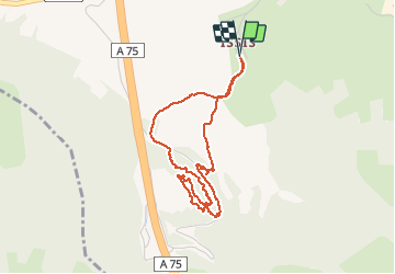

Length
4.1 km

Max alt
699 m

Uphill gradient
267 m
Km-Effort
7.7 km

Min alt
436 m

Downhill gradient
268 m
Boucle
Yes
Creation date :
2020-11-27 11:12:16.12
Updated on :
2020-11-27 12:54:36.86
1h42
Difficulty : Very easy

FREE GPS app for hiking
 SityTrail
IGN / Geographical institutes
SityTrail Plus
The world is yours!
About
Trail Walking of 4.1 km to be discovered at Occitania, Aveyron, Creissels. This trail is proposed by lablaquiere.
Positioning
Country:
France
Region :
Occitania
Department/Province :
Aveyron
Municipality :
Creissels
Location:
Unknown
Start:(Dec)
Start:(UTM)
502569 ; 4880206 (31T) N.
Comments