


Charnay

GOHIER
User
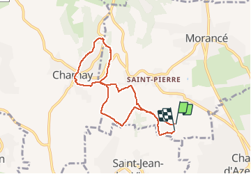

Length
7.7 km

Max alt
444 m

Uphill gradient
255 m
Km-Effort
11.1 km

Min alt
270 m

Downhill gradient
255 m
Boucle
Yes
Creation date :
2020-11-28 12:54:24.0
Updated on :
2020-11-28 15:04:18.679
2h09
Difficulty : Unknown

FREE GPS app for hiking
 SityTrail
IGN / Geographical institutes
SityTrail Plus
The world is yours!
About
Trail Nordic walking of 7.7 km to be discovered at Auvergne-Rhône-Alpes, Rhône, Morancé. This trail is proposed by GOHIER.
Positioning
Country:
France
Region :
Auvergne-Rhône-Alpes
Department/Province :
Rhône
Municipality :
Morancé
Location:
Unknown
Start:(Dec)
Start:(UTM)
631352 ; 5082434 (31T) N.
Comments