


verrieres

adubarry
User
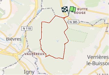

Length
6.1 km

Max alt
181 m

Uphill gradient
90 m
Km-Effort
7.3 km

Min alt
111 m

Downhill gradient
89 m
Boucle
Yes
Creation date :
2020-11-28 14:10:51.845
Updated on :
2020-11-28 15:45:54.096
1h34
Difficulty : Very easy

FREE GPS app for hiking
 SityTrail
IGN / Geographical institutes
SityTrail Plus
The world is yours!
About
Trail Walking of 6.1 km to be discovered at Ile-de-France, Hauts-de-Seine, Châtenay-Malabry. This trail is proposed by adubarry.
Positioning
Country:
France
Region :
Ile-de-France
Department/Province :
Hauts-de-Seine
Municipality :
Châtenay-Malabry
Location:
Unknown
Start:(Dec)
Start:(UTM)
444748 ; 5401432 (31U) N.
Comments