Ohain et Couture-Saint-Germain par les sentiers

Basile Bas
User
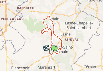

Length
10.7 km

Max alt
130 m

Uphill gradient
241 m
Km-Effort
13.9 km

Min alt
68 m

Downhill gradient
242 m
Boucle
Yes
Creation date :
2020-11-29 20:18:41.22
Updated on :
2020-12-13 16:22:38.477
--
Difficulty : Easy

FREE GPS app for hiking
 SityTrail
IGN / Geographical institutes
SityTrail Plus
The world is yours!
About
Trail On foot of 10.7 km to be discovered at Wallonia, Walloon Brabant, Lasne. This trail is proposed by Basile Bas.
Positioning
Country:
Belgium
Region :
Wallonia
Department/Province :
Walloon Brabant
Municipality :
Lasne
Location:
Lasne
Start:(Dec)
Start:(UTM)
603611 ; 5614182 (31U) N.
Comments