


trace-gpx-utds (1)

daniel_2w
User
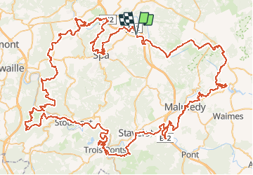

Length
157 km

Max alt
697 m

Uphill gradient
4130 m
Km-Effort
212 km

Min alt
160 m

Downhill gradient
4122 m
Boucle
Yes
Creation date :
2020-11-29 21:27:15.429
Updated on :
2020-11-29 21:29:46.956
--
Difficulty : Very difficult

FREE GPS app for hiking
 SityTrail
IGN / Geographical institutes
SityTrail Plus
The world is yours!
About
Trail Trail of 157 km to be discovered at Wallonia, Liège, Jalhay. This trail is proposed by daniel_2w.
Positioning
Country:
Belgium
Region :
Wallonia
Department/Province :
Liège
Municipality :
Jalhay
Location:
Sart
Start:(Dec)
Start:(UTM)
707909 ; 5600252 (31U) N.
Comments