


bois de Moure

Mascart
User
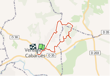

Length
7.5 km

Max alt
209 m

Uphill gradient
118 m
Km-Effort
9.1 km

Min alt
123 m

Downhill gradient
117 m
Boucle
Yes
Creation date :
2020-11-30 13:16:07.429
Updated on :
2020-11-30 16:26:45.448
2h10
Difficulty : Easy

FREE GPS app for hiking
 SityTrail
IGN / Geographical institutes
SityTrail Plus
The world is yours!
About
Trail Walking of 7.5 km to be discovered at Occitania, Aude, Ventenac-Cabardès. This trail is proposed by Mascart.
Description
impasse Galy
Positioning
Country:
France
Region :
Occitania
Department/Province :
Aude
Municipality :
Ventenac-Cabardès
Location:
Unknown
Start:(Dec)
Start:(UTM)
441991 ; 4790523 (31T) N.
Comments