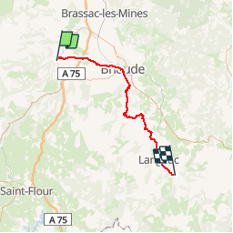
Blesle-St Arcons d'Allier

ARVIEU
User

Length
59 km

Max alt
737 m

Uphill gradient
1044 m
Km-Effort
73 km

Min alt
432 m

Downhill gradient
1002 m
Boucle
No
Creation date :
2014-12-10 00:00:00.0
Updated on :
2014-12-10 00:00:00.0
4h43
Difficulty : Medium

FREE GPS app for hiking
 SityTrail
IGN / Geographical institutes
SityTrail Plus
The world is yours!
About
Trail Mountain bike of 59 km to be discovered at Auvergne-Rhône-Alpes, Haute-Loire, Blesle. This trail is proposed by ARVIEU.
Description
Blesle-St Arcons d'Allier
Positioning
Country:
France
Region :
Auvergne-Rhône-Alpes
Department/Province :
Haute-Loire
Municipality :
Blesle
Location:
Unknown
Start:(Dec)
Start:(UTM)
514663 ; 5017650 (31T) N.
Comments