


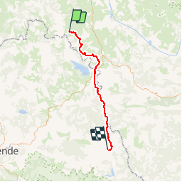
St Haon-Prévenchères

ARVIEU
User

Length
54 km

Max alt
1141 m

Uphill gradient
934 m
Km-Effort
67 km

Min alt
849 m

Downhill gradient
1081 m
Boucle
No
Creation date :
2014-12-10 00:00:00.0
Updated on :
2014-12-10 00:00:00.0
4h18
Difficulty : Medium

FREE GPS app for hiking
 SityTrail
IGN / Geographical institutes
SityTrail Plus
The world is yours!
About
Trail Mountain bike of 54 km to be discovered at Auvergne-Rhône-Alpes, Haute-Loire, Saint-Haon. This trail is proposed by ARVIEU.
Positioning
Country:
France
Region :
Auvergne-Rhône-Alpes
Department/Province :
Haute-Loire
Municipality :
Saint-Haon
Location:
Unknown
Start:(Dec)
Start:(UTM)
559881 ; 4966252 (31T) N.
Comments