


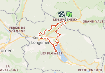
SURCENEUX LONGEMER...

surceneux
User

Length
12 km

Max alt
856 m

Uphill gradient
253 m
Km-Effort
15.4 km

Min alt
718 m

Downhill gradient
253 m
Boucle
Yes
Creation date :
2020-12-02 12:46:14.566
Updated on :
2020-12-02 15:42:45.195
2h27
Difficulty : Easy

FREE GPS app for hiking
 SityTrail
IGN / Geographical institutes
SityTrail Plus
The world is yours!
About
Trail Walking of 12 km to be discovered at Grand Est, Vosges, Ban-sur-Meurthe-Clefcy. This trail is proposed by surceneux.
Description
SURCENEUX LONGEMER BUTTE BILON XONRUPT CENTRE ROCHE DU PAGE BEHEUILLE SURCENEUX
Positioning
Country:
France
Region :
Grand Est
Department/Province :
Vosges
Municipality :
Ban-sur-Meurthe-Clefcy
Location:
Unknown
Start:(Dec)
Start:(UTM)
347818 ; 5329040 (32U) N.
Comments