


rossatiere col pilori

BELLETGE
User

Length
17.7 km

Max alt
913 m

Uphill gradient
566 m
Km-Effort
25 km

Min alt
455 m

Downhill gradient
566 m
Boucle
Yes
Creation date :
2020-12-03 09:31:34.273
Updated on :
2020-12-03 14:39:01.421
4h19
Difficulty : Easy

FREE GPS app for hiking
 SityTrail
IGN / Geographical institutes
SityTrail Plus
The world is yours!
About
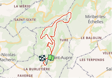
Trail Walking of 17.7 km to be discovered at Auvergne-Rhône-Alpes, Isère, Saint-Aupre. This trail is proposed by BELLETGE.
Positioning
Country:
France
Region :
Auvergne-Rhône-Alpes
Department/Province :
Isère
Municipality :
Saint-Aupre
Location:
Unknown
Start:(Dec)
Start:(UTM)
707755 ; 5030030 (31T) N.
Comments