


GASPARD BOUCLE

surceneux
User

Length
5.8 km

Max alt
928 m

Uphill gradient
190 m
Km-Effort
8.4 km

Min alt
761 m

Downhill gradient
190 m
Boucle
Yes
Creation date :
2020-12-04 14:33:25.069
Updated on :
2020-12-04 16:37:30.935
1h11
Difficulty : Very easy

FREE GPS app for hiking
 SityTrail
IGN / Geographical institutes
SityTrail Plus
The world is yours!
About
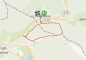
Trail Walking of 5.8 km to be discovered at Grand Est, Vosges, Ban-sur-Meurthe-Clefcy. This trail is proposed by surceneux.
Description
SURCENEUX GASPARD PORT DES PLANCHES LES BROCHES TRAVERSE JDS SURCENEUX
Positioning
Country:
France
Region :
Grand Est
Department/Province :
Vosges
Municipality :
Ban-sur-Meurthe-Clefcy
Location:
Unknown
Start:(Dec)
Start:(UTM)
347826 ; 5329037 (32U) N.
Comments