


oppidum

Bwattier
User
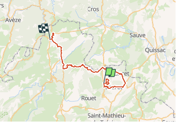

Length
48 km

Max alt
398 m

Uphill gradient
632 m
Km-Effort
57 km

Min alt
129 m

Downhill gradient
801 m
Boucle
No
Creation date :
2020-12-05 13:39:04.062
Updated on :
2020-12-05 17:17:55.95
3h38
Difficulty : Very easy

FREE GPS app for hiking
 SityTrail
IGN / Geographical institutes
SityTrail Plus
The world is yours!
About
Trail Walking of 48 km to be discovered at Occitania, Hérault, Claret. This trail is proposed by Bwattier.
Positioning
Country:
France
Region :
Occitania
Department/Province :
Hérault
Municipality :
Claret
Location:
Unknown
Start:(Dec)
Start:(UTM)
568898 ; 4854714 (31T) N.
Comments