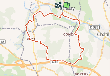
Chessy les mines (9,7 km - D. 253)

Thomasdanielle
User

Length
9.7 km

Max alt
391 m

Uphill gradient
253 m
Km-Effort
13.1 km

Min alt
214 m

Downhill gradient
253 m
Boucle
Yes
Creation date :
2020-12-07 12:54:24.0
Updated on :
2021-01-11 16:55:24.082
2h48
Difficulty : Unknown

FREE GPS app for hiking
 SityTrail
IGN / Geographical institutes
SityTrail Plus
The world is yours!
About
Trail Walking of 9.7 km to be discovered at Auvergne-Rhône-Alpes, Rhône, Chessy. This trail is proposed by Thomasdanielle.
Description
D/A : Parking en face de l'école, après le passage à niveau
Marche sans difficulté
Positioning
Country:
France
Region :
Auvergne-Rhône-Alpes
Department/Province :
Rhône
Municipality :
Chessy
Location:
Unknown
Start:(Dec)
Start:(UTM)
625723 ; 5082622 (31T) N.
Comments