


2020-12-08 Ris Saint Fargeau Ris

Lucquiaud
User
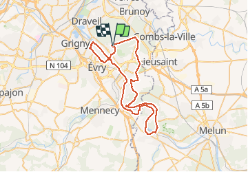

Length
61 km

Max alt
97 m

Uphill gradient
597 m
Km-Effort
69 km

Min alt
26 m

Downhill gradient
596 m
Boucle
Yes
Creation date :
2020-12-07 16:36:43.236
Updated on :
2020-12-07 17:00:52.291
--
Difficulty : Medium

FREE GPS app for hiking
 SityTrail
IGN / Geographical institutes
SityTrail Plus
The world is yours!
About
Trail Cycle of 61 km to be discovered at Ile-de-France, Essonne, Soisy-sur-Seine. This trail is proposed by Lucquiaud.
Positioning
Country:
France
Region :
Ile-de-France
Department/Province :
Essonne
Municipality :
Soisy-sur-Seine
Location:
Unknown
Start:(Dec)
Start:(UTM)
460400 ; 5388928 (31U) N.
Comments