


Séné

marchaisp
User
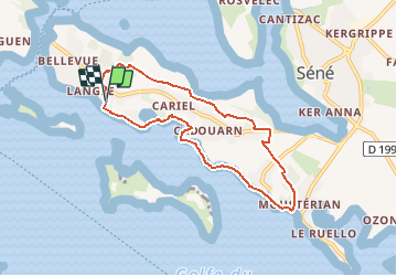

Length
7.1 km

Max alt
15 m

Uphill gradient
36 m
Km-Effort
7.6 km

Min alt
-1 m

Downhill gradient
33 m
Boucle
Yes
Creation date :
2020-12-09 18:54:02.456
Updated on :
2020-12-09 18:54:24.588

FREE GPS app for hiking
 SityTrail
IGN / Geographical institutes
SityTrail Plus
The world is yours!
About
Trail of 7.1 km to be discovered at Brittany, Morbihan, Séné. This trail is proposed by marchaisp.


Positioning
Country:
France
Region :
Brittany
Department/Province :
Morbihan
Municipality :
Séné
Location:
Unknown
Start:(Dec)
Start:(UTM)
517299 ; 5273734 (30T) N.
Comments