


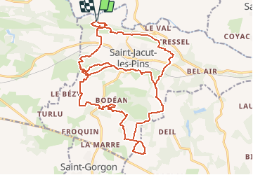
10/12/2020 - Autour de ST JACUT LES PINS.Virtuel

babeth35
User

Length
27 km

Max alt
91 m

Uphill gradient
411 m
Km-Effort
33 km

Min alt
11 m

Downhill gradient
412 m
Boucle
Yes
Creation date :
2020-12-10 17:50:03.941
Updated on :
2020-12-12 17:08:25.777
--
Difficulty : Medium
51m
Difficulty : Easy

FREE GPS app for hiking
 SityTrail
IGN / Geographical institutes
SityTrail Plus
The world is yours!
About
Trail On foot of 27 km to be discovered at Brittany, Morbihan, Saint-Jacut-les-Pins. This trail is proposed by babeth35.
Positioning
Country:
France
Region :
Brittany
Department/Province :
Morbihan
Municipality :
Saint-Jacut-les-Pins
Location:
Unknown
Start:(Dec)
Start:(UTM)
557543 ; 5282899 (30T) N.
Comments