


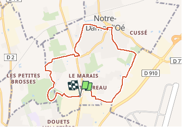
Notre-Dame-d'Oé - PR sud - 8.8km 60m 1h50 - 2020 12 12

Orcal37
User GUIDE

Length
8.8 km

Max alt
109 m

Uphill gradient
60 m
Km-Effort
9.6 km

Min alt
88 m

Downhill gradient
60 m
Boucle
Yes
Creation date :
2020-12-12 13:00:56.146
Updated on :
2020-12-12 17:32:33.185
1h50
Difficulty : Very easy

FREE GPS app for hiking
 SityTrail
IGN / Geographical institutes
SityTrail Plus
The world is yours!
About
Trail Walking of 8.8 km to be discovered at Centre-Loire Valley, Indre-et-Loire, Notre-Dame-d'Oé. This trail is proposed by Orcal37.
Description
Notre-Dame-d'Oé - PR sud - 8.8km 60m 1h50 - 2020 12 12
Photos


Positioning
Country:
France
Region :
Centre-Loire Valley
Department/Province :
Indre-et-Loire
Municipality :
Notre-Dame-d'Oé
Location:
Unknown
Start:(Dec)
Start:(UTM)
326524 ; 5256633 (31T) N.
Comments