


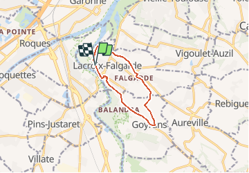
Lacroix Goyrans sans boue?

pidjam
User

Length
9.2 km

Max alt
275 m

Uphill gradient
163 m
Km-Effort
11.4 km

Min alt
148 m

Downhill gradient
161 m
Boucle
Yes
Creation date :
2020-12-13 09:37:13.022
Updated on :
2020-12-13 09:37:37.334
2h27
Difficulty : Medium

FREE GPS app for hiking
 SityTrail
IGN / Geographical institutes
SityTrail Plus
The world is yours!
About
Trail Walking of 9.2 km to be discovered at Occitania, Haute-Garonne, Lacroix-Falgarde. This trail is proposed by pidjam.
Positioning
Country:
France
Region :
Occitania
Department/Province :
Haute-Garonne
Municipality :
Lacroix-Falgarde
Location:
Unknown
Start:(Dec)
Start:(UTM)
371129 ; 4817908 (31T) N.
Comments