


2020-12-12 ris ponthierry ris 60 km

Lucquiaud
User
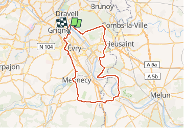

Length
59 km

Max alt
95 m

Uphill gradient
511 m
Km-Effort
65 km

Min alt
25 m

Downhill gradient
511 m
Boucle
Yes
Creation date :
2020-12-13 08:28:11.298
Updated on :
2020-12-13 11:14:40.124
2h45
Difficulty : Easy

FREE GPS app for hiking
 SityTrail
IGN / Geographical institutes
SityTrail Plus
The world is yours!
About
Trail Road bike of 59 km to be discovered at Ile-de-France, Essonne, Ris-Orangis. This trail is proposed by Lucquiaud.
Positioning
Country:
France
Region :
Ile-de-France
Department/Province :
Essonne
Municipality :
Ris-Orangis
Location:
Unknown
Start:(Dec)
Start:(UTM)
456998 ; 5388483 (31U) N.
Comments