


pichaury j.f

NADINE52
User
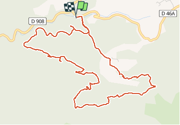

Length
7.5 km

Max alt
443 m

Uphill gradient
194 m
Km-Effort
10.1 km

Min alt
298 m

Downhill gradient
192 m
Boucle
Yes
Creation date :
2020-12-13 08:59:11.289
Updated on :
2020-12-13 11:28:26.518
2h28
Difficulty : Very easy

FREE GPS app for hiking
 SityTrail
IGN / Geographical institutes
SityTrail Plus
The world is yours!
About
Trail Walking of 7.5 km to be discovered at Provence-Alpes-Côte d'Azur, Bouches-du-Rhône, Allauch. This trail is proposed by NADINE52.
Photos


Positioning
Country:
France
Region :
Provence-Alpes-Côte d'Azur
Department/Province :
Bouches-du-Rhône
Municipality :
Allauch
Location:
Unknown
Start:(Dec)
Start:(UTM)
705466 ; 4805081 (31T) N.
Comments