


cades

lablaquiere
User

Length
3.8 km

Max alt
851 m

Uphill gradient
70 m
Km-Effort
4.7 km

Min alt
790 m

Downhill gradient
75 m
Boucle
No
Creation date :
2020-12-13 15:31:05.58
Updated on :
2020-12-13 16:44:28.973
1h13
Difficulty : Very easy

FREE GPS app for hiking
 SityTrail
IGN / Geographical institutes
SityTrail Plus
The world is yours!
About
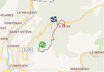
Trail Walking of 3.8 km to be discovered at Occitania, Aveyron, Millau. This trail is proposed by lablaquiere.
Positioning
Country:
France
Region :
Occitania
Department/Province :
Aveyron
Municipality :
Millau
Location:
Unknown
Start:(Dec)
Start:(UTM)
508279 ; 4884119 (31T) N.
Comments