Trail  Faverois - SityTrail - Circuit de Faverois - Photo
 bubu90
bubu90

User

© OpenStreetMap contributors
Length
Length
6.9 km
Max alt
Max alt
416 m
Uphill gradient
Uphill gradient
78 m
Km-Effort
Km-Effort  
8 km
Min alt
Min alt
380 m
Downhill gradient
Downhill gradient
80 m
Boucle
Boucle
Yes
Creation date :
2020-12-16 10:27:37.882
Updated on :
2020-12-16 10:29:50.771

(0 Reviews)


Scan this QR Code to open this trail in the SityTrail application

FREE GPS app for hiking

Logo SityTrail SityTrail

IGN / Geographical institutes

Download SityTrail from the App Store Download SityTrail from Google Play

Logo SityTrail SityTrail Plus

The world is yours!

Download SityTrail from the App Store Download SityTrail from Google Play Download SityTrail on Huawei AppGallery

About

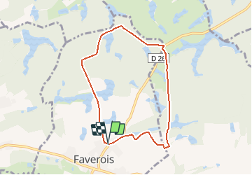
Trail of 6.9 km to be discovered at Bourgogne-Franche-Comté, Territoire-de-Belfort, Faverois. This trail is proposed by bubu90.

Description

Circuit proposé par la Communauté de Communes du Sud Territoire. Départ du parking de la salle communale de Faverois. Retrouvez ce circuit sur le site de la communauté de communes du Sud Territoire.

Elevation profile

Positioning

Country:
France
Region :
Bourgogne-Franche-Comté
Department/Province :
Territoire-de-Belfort
Municipality :
Faverois
Location:
Unknown
Start:(UTM)
352338 ; 5265368 (32T) N.


Close
My subscriptions