


Pic de Château renard

orsel
User GUIDE
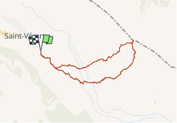

Length
8.7 km

Max alt
2961 m

Uphill gradient
943 m
Km-Effort
21 km

Min alt
2011 m

Downhill gradient
946 m
Boucle
Yes
Creation date :
2020-12-17 07:52:11.623
Updated on :
2020-12-17 17:34:24.242
6h25
Difficulty : Easy

FREE GPS app for hiking
 SityTrail
IGN / Geographical institutes
SityTrail Plus
The world is yours!
About
Trail Touring skiing of 8.7 km to be discovered at Provence-Alpes-Côte d'Azur, Hautes-Alpes, Saint-Véran. This trail is proposed by orsel.
Positioning
Country:
France
Region :
Provence-Alpes-Côte d'Azur
Department/Province :
Hautes-Alpes
Municipality :
Saint-Véran
Location:
Unknown
Start:(Dec)
Start:(UTM)
331618 ; 4951338 (32T) N.
Comments