


blois stade des allees

gerardh
User
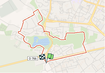

Length
5.2 km

Max alt
119 m

Uphill gradient
45 m
Km-Effort
5.8 km

Min alt
94 m

Downhill gradient
46 m
Boucle
Yes
Creation date :
2020-12-22 08:21:29.594
Updated on :
2020-12-22 08:22:29.842
1h16
Difficulty : Easy

FREE GPS app for hiking
 SityTrail
IGN / Geographical institutes
SityTrail Plus
The world is yours!
About
Trail Walking of 5.2 km to be discovered at Centre-Loire Valley, Loir-et-Cher, Blois. This trail is proposed by gerardh.
Description
parc de l arrou
lac
Positioning
Country:
France
Region :
Centre-Loire Valley
Department/Province :
Loir-et-Cher
Municipality :
Blois
Location:
Unknown
Start:(Dec)
Start:(UTM)
372061 ; 5271170 (31T) N.
Comments