


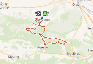
Eygalieres / Les Alpilles

mthomas30
User

Length
37 km

Max alt
347 m

Uphill gradient
901 m
Km-Effort
49 km

Min alt
98 m

Downhill gradient
901 m
Boucle
Yes
Creation date :
2020-12-22 07:26:24.446
Updated on :
2021-02-01 22:07:55.827
4h01
Difficulty : Difficult

FREE GPS app for hiking
 SityTrail
IGN / Geographical institutes
SityTrail Plus
The world is yours!
About
Trail Mountain bike of 37 km to be discovered at Provence-Alpes-Côte d'Azur, Bouches-du-Rhône, Eygalières. This trail is proposed by mthomas30.
Description
2 petits portages pour savourer les monotraces à la descente.
Positioning
Country:
France
Region :
Provence-Alpes-Côte d'Azur
Department/Province :
Bouches-du-Rhône
Municipality :
Eygalières
Location:
Unknown
Start:(Dec)
Start:(UTM)
656755 ; 4847163 (31T) N.
Comments