


Chamrousse

GOHIER
User
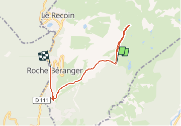

Length
5.8 km

Max alt
2202 m

Uphill gradient
140 m
Km-Effort
8.9 km

Min alt
1715 m

Downhill gradient
490 m
Boucle
No
Creation date :
2020-12-22 11:03:28.0
Updated on :
2020-12-22 12:36:46.997
1h33
Difficulty : Unknown

FREE GPS app for hiking
 SityTrail
IGN / Geographical institutes
SityTrail Plus
The world is yours!
About
Trail Touring skiing of 5.8 km to be discovered at Auvergne-Rhône-Alpes, Isère, Chamrousse. This trail is proposed by GOHIER.
Positioning
Country:
France
Region :
Auvergne-Rhône-Alpes
Department/Province :
Isère
Municipality :
Chamrousse
Location:
Unknown
Start:(Dec)
Start:(UTM)
727888 ; 4999777 (31T) N.
Comments