


Millery

Bernadette Noirant
User
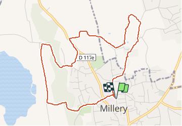

Length
5.6 km

Max alt
290 m

Uphill gradient
119 m
Km-Effort
7.2 km

Min alt
198 m

Downhill gradient
119 m
Boucle
Yes
Creation date :
2020-12-24 15:14:00.105
Updated on :
2020-12-24 16:01:21.816
46m
Difficulty : Easy

FREE GPS app for hiking
 SityTrail
IGN / Geographical institutes
SityTrail Plus
The world is yours!
About
Trail Running of 5.6 km to be discovered at Auvergne-Rhône-Alpes, Rhône, Millery. This trail is proposed by Bernadette Noirant.
Description
course à pied
Positioning
Country:
France
Region :
Auvergne-Rhône-Alpes
Department/Province :
Rhône
Municipality :
Millery
Location:
Unknown
Start:(Dec)
Start:(UTM)
638797 ; 5055016 (31T) N.
Comments