


MARCINELLE - ORET

pjennes
User
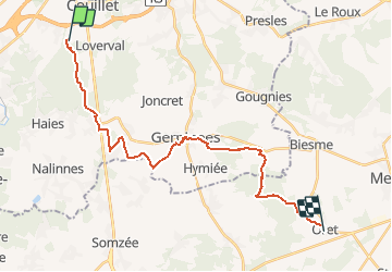

Length
23 km

Max alt
272 m

Uphill gradient
345 m
Km-Effort
27 km

Min alt
156 m

Downhill gradient
281 m
Boucle
No
Creation date :
2020-12-25 09:56:58.025
Updated on :
2020-12-25 09:59:38.028
5h54
Difficulty : Medium

FREE GPS app for hiking
 SityTrail
IGN / Geographical institutes
SityTrail Plus
The world is yours!
About
Trail Walking of 23 km to be discovered at Wallonia, Hainaut, Charleroi. This trail is proposed by pjennes.
Description
Par un max de GR
Positioning
Country:
Belgium
Region :
Wallonia
Department/Province :
Hainaut
Municipality :
Charleroi
Location:
Marcinelle
Start:(Dec)
Start:(UTM)
603414 ; 5581532 (31U) N.
Comments