


sortie à pieds 25122020

fabwin
User GUIDE
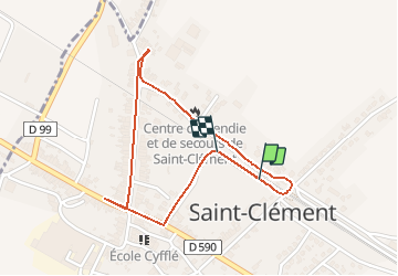

Length
2 km

Max alt
248 m

Uphill gradient
7 m
Km-Effort
2.1 km

Min alt
243 m

Downhill gradient
8 m
Boucle
Yes
Creation date :
2020-12-25 13:53:44.309
Updated on :
2020-12-25 14:15:03.98
10m
Difficulty : Very easy

FREE GPS app for hiking
 SityTrail
IGN / Geographical institutes
SityTrail Plus
The world is yours!
About
Trail Walking of 2 km to be discovered at Grand Est, Meurthe-et-Moselle, Saint-Clément. This trail is proposed by fabwin.
Description
Elimination des excès!!
Positioning
Country:
France
Region :
Grand Est
Department/Province :
Meurthe-et-Moselle
Municipality :
Saint-Clément
Location:
Unknown
Start:(Dec)
Start:(UTM)
323331 ; 5378163 (32U) N.
Comments