


DE ORET A LA MEUSE - PONT d'YVOIR PAR GR ET AUTRES VOIES

pjennes
User
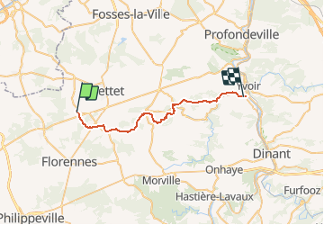

Length
26 km

Max alt
283 m

Uphill gradient
388 m
Km-Effort
32 km

Min alt
86 m

Downhill gradient
514 m
Boucle
No
Creation date :
2020-12-25 16:33:24.542
Updated on :
2020-12-25 16:35:52.237
--
Difficulty : Medium
6h53
Difficulty : Medium

FREE GPS app for hiking
 SityTrail
IGN / Geographical institutes
SityTrail Plus
The world is yours!
About
Trail On foot of 26 km to be discovered at Wallonia, Namur, Mettet. This trail is proposed by pjennes.
Positioning
Country:
Belgium
Region :
Wallonia
Department/Province :
Namur
Municipality :
Mettet
Location:
Oret
Start:(Dec)
Start:(UTM)
615059 ; 5573216 (31U) N.
Comments