


Lenion

oliviergau
User
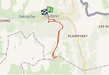

Length
13.8 km

Max alt
2501 m

Uphill gradient
1013 m
Km-Effort
27 km

Min alt
1580 m

Downhill gradient
1029 m
Boucle
No
Creation date :
2020-12-26 08:47:40.368
Updated on :
2020-12-26 16:48:40.641
3h53
Difficulty : Very easy

FREE GPS app for hiking
 SityTrail
IGN / Geographical institutes
SityTrail Plus
The world is yours!
About
Trail Touring skiing of 13.8 km to be discovered at Provence-Alpes-Côte d'Azur, Hautes-Alpes, Névache. This trail is proposed by oliviergau.
Positioning
Country:
France
Region :
Provence-Alpes-Côte d'Azur
Department/Province :
Hautes-Alpes
Municipality :
Névache
Location:
Unknown
Start:(Dec)
Start:(UTM)
312902 ; 4987802 (32T) N.
Comments