


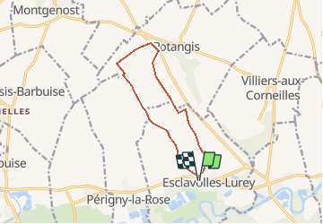
Esclavolles Esclavolles via éoliennes et Potangis

Patrick Castagne
User

Length
10.1 km

Max alt
132 m

Uphill gradient
135 m
Km-Effort
11.9 km

Min alt
70 m

Downhill gradient
135 m
Boucle
Yes
Creation date :
2020-12-27 15:14:40.215
Updated on :
2020-12-27 15:19:10.42
2h36
Difficulty : Medium

FREE GPS app for hiking
 SityTrail
IGN / Geographical institutes
SityTrail Plus
The world is yours!
About
Trail Walking of 10.1 km to be discovered at Grand Est, Marne, Esclavolles-Lurey. This trail is proposed by Patrick Castagne.
Description
Balade dans les champs d'eoliennes
Positioning
Country:
France
Region :
Grand Est
Department/Province :
Marne
Municipality :
Esclavolles-Lurey
Location:
Unknown
Start:(Dec)
Start:(UTM)
548169 ; 5377993 (31U) N.
Comments