


Mamer ii

šarūnas
User
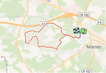

Length
6.9 km

Max alt
338 m

Uphill gradient
87 m
Km-Effort
8 km

Min alt
290 m

Downhill gradient
83 m
Boucle
Yes
Creation date :
2020-12-27 14:11:12.0
Updated on :
2020-12-27 15:23:32.971
1h10
Difficulty : Unknown

FREE GPS app for hiking
 SityTrail
IGN / Geographical institutes
SityTrail Plus
The world is yours!
About
Trail Walking of 6.9 km to be discovered at Unknown, Canton Capellen, Mamer. This trail is proposed by šarūnas.
Positioning
Country:
Luxembourg
Region :
Unknown
Department/Province :
Canton Capellen
Municipality :
Mamer
Location:
Mamer
Start:(Dec)
Start:(UTM)
284414 ; 5501785 (32U) N.
Comments