Trail Walking Châtelus - grotte de pabro  - Photo
 bymarc26
bymarc26

User

© OpenStreetMap contributors
Length
Length
6.9 km
Max alt
Max alt
1131 m
Uphill gradient
Uphill gradient
748 m
Km-Effort
Km-Effort  
16.9 km
Min alt
Min alt
532 m
Downhill gradient
Downhill gradient
747 m
Boucle
Boucle
Yes
Creation date :
2014-12-10 00:00:00.0
Updated on :
2014-12-10 00:00:00.0

(0 Reviews)

Walking
Walking
3h27
Difficulty : Very difficult

Scan this QR Code to open this trail in the SityTrail application

FREE GPS app for hiking

Logo SityTrail SityTrail

IGN / Geographical institutes

Download SityTrail from the App Store Download SityTrail from Google Play

Logo SityTrail SityTrail Plus

The world is yours!

Download SityTrail from the App Store Download SityTrail from Google Play Download SityTrail on Huawei AppGallery

About

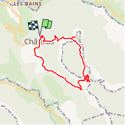
Trail Walking of 6.9 km to be discovered at Auvergne-Rhône-Alpes, Isère, Châtelus. This trail is proposed by bymarc26.

Description

montée depuis chatelus vers le pas de pabro - détour jusqu'à la grotte de pabro - montée sur le plateau de la grande cournouse (attention très difficile même si des cordes sont installées) retour par le pas des voûtes

Elevation profile

Positioning

Country:
France
Region :
Auvergne-Rhône-Alpes
Department/Province :
Isère
Municipality :
Châtelus
Location:
Unknown
Start:(UTM)
686885 ; 4992091 (31T) N.


Close
My subscriptions