


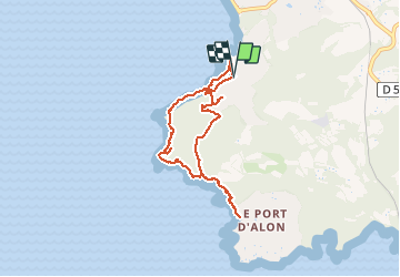
Boucle Port Madrague St Cyr sur Mer

cousam
User

Length
7.4 km

Max alt
111 m

Uphill gradient
236 m
Km-Effort
10.5 km

Min alt
0 m

Downhill gradient
231 m
Boucle
Yes
Creation date :
2020-12-29 12:56:29.62
Updated on :
2021-04-13 16:49:26.084
1h57
Difficulty : Medium

FREE GPS app for hiking
 SityTrail
IGN / Geographical institutes
SityTrail Plus
The world is yours!
About
Trail Walking of 7.4 km to be discovered at Provence-Alpes-Côte d'Azur, Var, Saint-Cyr-sur-Mer. This trail is proposed by cousam.
Photos


Positioning
Country:
France
Region :
Provence-Alpes-Côte d'Azur
Department/Province :
Var
Municipality :
Saint-Cyr-sur-Mer
Location:
Unknown
Start:(Dec)
Start:(UTM)
719067 ; 4782653 (31T) N.
Comments