


fontaine de la Barbade st germain

lablaquiere
User
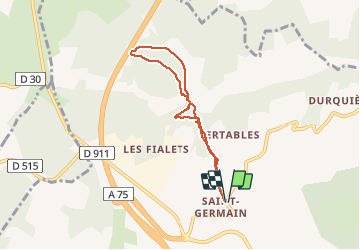

Length
6.2 km

Max alt
665 m

Uphill gradient
168 m
Km-Effort
8.4 km

Min alt
565 m

Downhill gradient
167 m
Boucle
Yes
Creation date :
2020-12-29 15:03:40.852
Updated on :
2020-12-29 16:11:11.054
1h07
Difficulty : Very easy

FREE GPS app for hiking
 SityTrail
IGN / Geographical institutes
SityTrail Plus
The world is yours!
About
Trail Walking of 6.2 km to be discovered at Occitania, Aveyron, Millau. This trail is proposed by lablaquiere.
Positioning
Country:
France
Region :
Occitania
Department/Province :
Aveyron
Municipality :
Millau
Location:
Unknown
Start:(Dec)
Start:(UTM)
503112 ; 4887182 (31T) N.
Comments