


BEHEUILLE MOITIE AR

surceneux
User
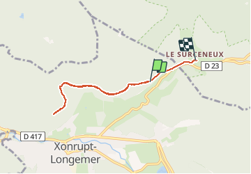

Length
6.1 km

Max alt
904 m

Uphill gradient
91 m
Km-Effort
7.4 km

Min alt
815 m

Downhill gradient
122 m
Boucle
No
Creation date :
2020-12-29 13:53:02.986
Updated on :
2020-12-29 16:35:07.802
1h30
Difficulty : Very easy

FREE GPS app for hiking
 SityTrail
IGN / Geographical institutes
SityTrail Plus
The world is yours!
About
Trail Cross-country skiing of 6.1 km to be discovered at Grand Est, Vosges, Xonrupt-Longemer. This trail is proposed by surceneux.
Description
BEHEUILLE MOITIE AR
Positioning
Country:
France
Region :
Grand Est
Department/Province :
Vosges
Municipality :
Xonrupt-Longemer
Location:
Unknown
Start:(Dec)
Start:(UTM)
347004 ; 5328677 (32U) N.
Comments