


Thuin

Manu. Lemal
User
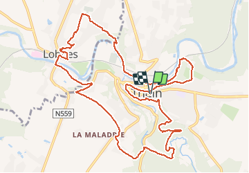

Length
13.4 km

Max alt
185 m

Uphill gradient
301 m
Km-Effort
17.4 km

Min alt
108 m

Downhill gradient
303 m
Boucle
Yes
Creation date :
2021-01-03 10:20:48.0
Updated on :
2021-01-03 13:39:11.911
3h18
Difficulty : Unknown

FREE GPS app for hiking
 SityTrail
IGN / Geographical institutes
SityTrail Plus
The world is yours!
About
Trail Walking of 13.4 km to be discovered at Wallonia, Hainaut, Thuin. This trail is proposed by Manu. Lemal.
Positioning
Country:
Belgium
Region :
Wallonia
Department/Province :
Hainaut
Municipality :
Thuin
Location:
Thuin
Start:(Dec)
Start:(UTM)
591655 ; 5577189 (31U) N.
Comments